TERCLIM 2026 - Maintaining the typicity of wines in a context of climate change: the impact of delimitation – example of the Côte Roannaise PDO
 Introduction to the “Côte Roannaise” PDO
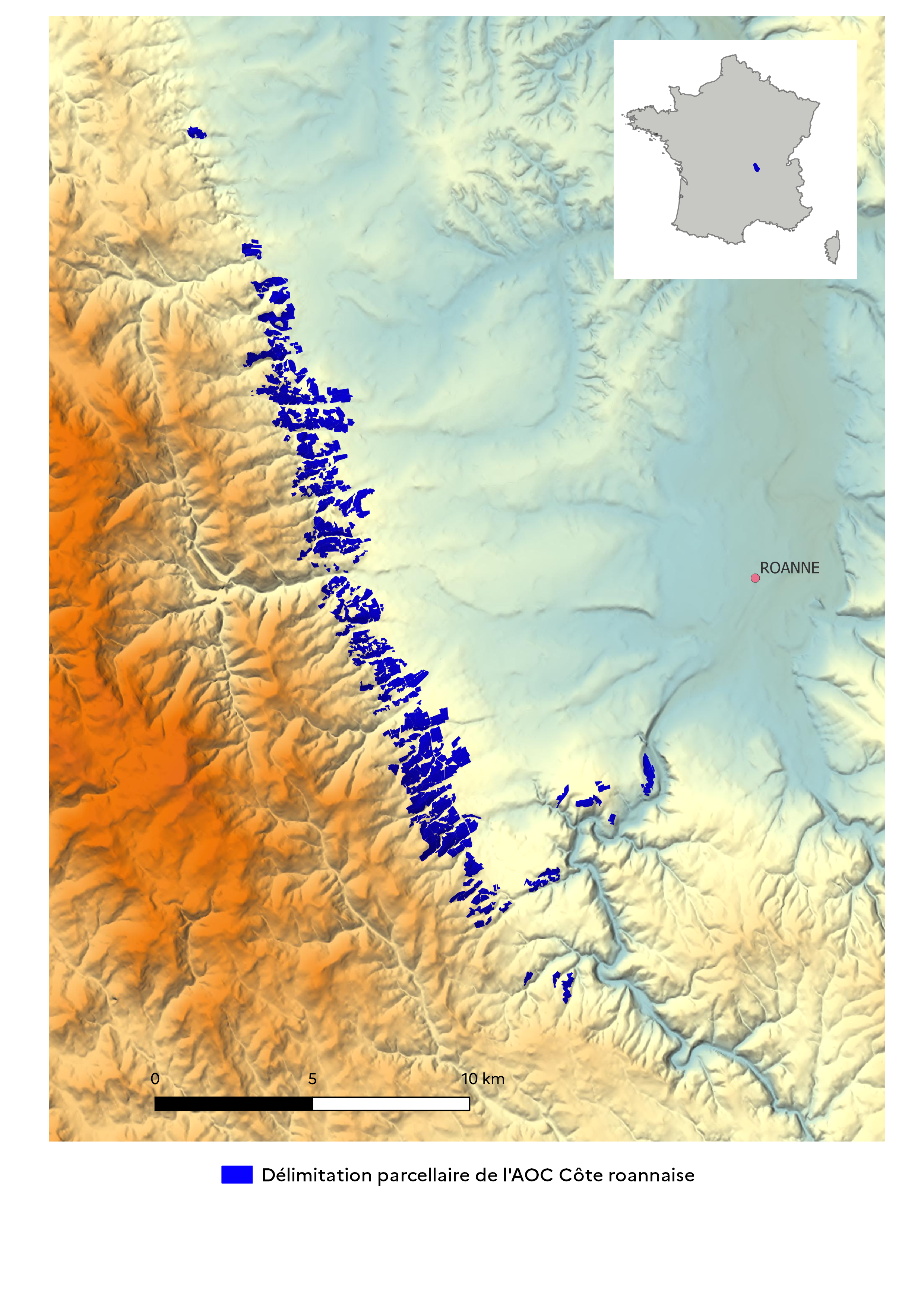
Located in the Loire department (France), at the foot of the Monts de la Madeleine, the "Côte Roannaise" PDO is renowned for its red and rosé wines.
The specifications define the boundaries where the grapes must be grown. Altitude is the primary delimitation criterion: it ranges from 380 to 550 meters in the current boundary, and north-facing slopes are avoided. Since the soils in the area are very homogeneous, soil type is only a secondary criterion.
Context and challenge
Producers in the appellation have observed that climate change is altering the distinctive character of their wines, all made from “Gamay Saint-Romain,” to which they are deeply attached. To preserve it, they asked the INAO to revise the parcel boundaries: a first in France to adapt to the climate. The idea: move to higher altitudes to compensate for early ripening and limit spring frosts, which are more frequent at the bottom of the hillside. A commission of experts has been appointed to work toward this goal.
Methodology and Initial Results
Agroclimatic Study: What Altitude Variations Are Possible for the Current Boundaries, Taking Climate Change Models into Account?
Conducted over the period 1995–2024, with projections through 2050–2100 based on the RCP4.5 and RCP8.5 scenarios, the study confirms the observations of winegrowers:
| Current Situation 1995–2024 | Outlook 2029–2050 | Horizon 2079–2100 |
Elevation ≈ 620m | Cool | Temperate | Warm temperate |
Mid-slope | Cool to temperate | Temperate (upper limit with RCP8.5) | Warm temperate (upper limit with RCP8.5) |
Plain / lower hillside | Temperate | Temperate (upper limit) | Warm temperate to hot |
Expected climate type (based on the Huglin index)
The favorable types for Gamay range from cool to temperate.
Modeling of energy received as a function of temperature and exposure
The energy received by the vine determines the ripeness of the grapes. Based on the energy balance of the vine canopy at a given moment, the relationship between radiation and air temperature at the vine level was calculated.
View the detailed calculation - french version (format PDF / 1449ko)
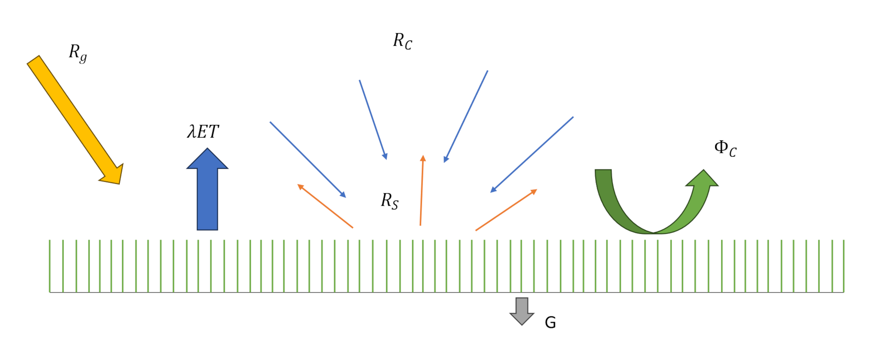
This allows us to calculate the theoretical amount of solar energy received by the vineyard at Roanne’s latitude, on an hourly basis and for each ten-day period, from early July to late September, for different slope gradients and orientations.
From this, we can determine the theoretical elevation to which the vineyard would need to be moved for a given slope and aspect so that it receives, on average, the same amount of solar energy as a south-facing vineyard with the same slope:
| SE (or SW) | E (or W) | NE (or NW) | N |
2,5% | -2m | -8m | -14m | -16m |
5% | -5m | -16m | -27m | -32m |
10% | -9m | -32m | -54m | -63m |
15% | -14m | -47m | -80m | -94m |
20% | -18m | -62m | -106m | -124m |
50% | -41m | -129m | -230m | -283m |
Altitude variation to be considered between a south-facing slope and another slope with equivalent gradient
Incorporating field measurements to refine modeling and delineation choices
Four sensors were installed in the vineyard, at elevations ranging from 390 to 620 meters, to record temperatures over the course of a year. The data will be available in the summer of 2026. Objectives:
- Analyze local temperature variability and the risk of spring frost based on altitude.
- Determine new altitude limits for vineyards, relevant for the coming decades.
Conclusion
By cross-referencing all these results, experts will determine new desirable altitude limits for vineyard establishment based on aspect and slope.
The presented method could be replicated in other midmountain vineyards seeking to adapt their boundaries to climate change.
Additional information
View full poster (PDF / 6,2mo)